
CHAPTER 41
Watching Punta Arenas fade in our rearview mirror felt good. It would have been a quick departure, but I realized we would be negligent not to stop and replace a few items that we had “sold” at the feria- a tire iron, some simple screwdrivers and wrenches, basically the bare minimum number of tools we might need if we happened to break down on the road- we were still in the middle of Patagonia after all. A few stores later, and we were finally back on the highway for more adventure. The first place on our list to see was the iconic summit of Mt. Fitzroy- an enormous granite spire thrusting up through the glacier carved valleys of the Andes. To get to El Chaltén, the small village at the base of the mountain, and the only access point for anyone planning to hike or climb in the surrounding national park, we had to cross the border, yet again, into Argentina. On a map of this area of Patagonia, the border between Argentina and Chile is marked with a dashed line, rather than the customary solid line. Starting at the summit of Mt. Fitzroy and running roughly south for about 100miles through the National Park, the border is apparently still under dispute. This surprised me a bit, considering how long these two countries have been around, but this strange anomaly actually fits right in to the atypical saga of international politics in South America.
Argentina and Chile have a colorful, if not tumultuous, history of international relations. The two countries started as Spanish colonies, though the interests of the local Spanish authorities were often pitted against one another. The first part of the 19th century saw the unraveling of Spanish colonial rule throughout the Americas, and after the successful independence of Argentina, the Argentine revolutionary general, Jose de San Martin, marched his troops over the high peaks of the Andes and promptly liberated Chile as well. Any goodwill garnered by this magnanimous undertaking was soon lost, and the relations between the two republics soured due to controversy over their largely undefined boarder. Both countries went so far as to claim the entire southern portion of the continent from coast to coast, but ultimately a war between Peru, Bolivia, and Chile (the 1879 War of the Pacific) led the later to seek an appeasing agreement with Argentina in regards to the indeterminate shared boarder, lest Argentina join forces with Bolivia and Peru against Chile. Unsurprisingly, the two sides had a hard time coming to an equitable solution, and decided to bring in a neutral third party to mediate.
The US ambassador to Chile stepped up to the plate to fill this role, even though America’s status as “neutral” could be debated. We had our own designs for the southern tip of South America and they didn’t involve either of the countries controlling the sea lanes through the Straights of Magellan, the only sea route from the East to the West coast of America at that time. Who knows what shady dealings went on behind closed doors, but when the Boundary Treaty of 1881 was signed, the southern continent was roughly divided down the backbone of the Andes all the way to the island of Tierra del Fuego where the border blatantly disregards any pretense of geographical boundaries, and cuts the straights, and the island, in half, thus ensuring America’s goal of not having any one country control that vital passageway. And due to the fact that those southern regions were largely unexplored in 1881, let alone surveyed, there are some sections of this ambiguous boarder that are still in dispute today.
Aside from the undeniable amount of discord this state of affairs has caused between the two countries, it presented a rather annoying situation for us: to see the sights of Patagonia, indeed to make it all the way south to Ushuaia, we ended up crossing the border between Chile and Argentina a total of nine times. And every time, we were required to jettison any extra fuel we had, we were searched for contraband meat, dairy, and plant byproducts, and our passports were bludgeoned with the inky smears of two immigration stamps- an exit stamp for one country, and an entry stamp for the next. Two stamps, times nine crossings, and our passports were filling up worryingly quickly- it was almost as many stamps as we had received from all the other border crossings during the whole trip. I was fortunate enough to already have extra pages added to my passport when I was working in Brazil, but Kacey was definitely not in the same boat. We counted her remaining blank spaces, and realized that she was going to come up short on room (it didn’t help that I had convinced her to get a commemorative “we made it to the end of the world” stamp at the post office in Ushuaia- but in my defense, we hadn’t tallied up how many stamp spaces we would need at that point). The only place to get extra pages added is at the US Embassy, the nearest ones being in Santiago, or Buenos Aires, both more than 2000 miles away. This presented a small problem when after her final spot was filled while exiting Chile one afternoon, we arrived at the Argentina entry post a few minutes later, and the sour faced border guard flatly told us that Kacey couldn’t come in to the country.
“What??! What the hell are we supposed to do??” I exclaimed in my brain. Luckily we had become quite adept at dealing with inept boarder officials, thus I didn’t say this out loud. I supinely asked him what exactly we needed to do, and when he answered that we would obviously have to get more pages added to the passport, we calmly explained that the only place to do that was in BA, and we couldn’t get there unless he let us in to Argentina. Finally we convinced him to place his mark in a small area between some other stamps, even though they would overlap slightly. He reluctantly pressed the stamp to the page, and gave us a look like he had done us the biggest favor in the world. I don’t see why overlapping stamps was such a big deal for him- scores of other officials had done as much or worse on previous pages. I think he was just bitter at being stationed to a post in the deserted wilds of Patagonia, and he took pleasure in passing along his misfortune to other people by abusing the small amount of power he had over us.
The border with Chile is not Argentina’s only territorial grievance. Another manifestation of their inherent belief in sovereign rule, over a place that they don’t actually have any authority, are the Islas Malvinas, or Falkland Islands to the rest of us. Though they fought, and lost, a small war over these strategic islands in the 1980’s, there is still a deep seated conviction felt by the majority of the country that Argentina is the rightful owner of the Falklands. This sentiment is so omnipresent that you could probably say that it is a part of their national identity. From Iguazu Falls in the north, all the way to Ushuaia in the south, there are hundreds of big blue signs along the highways that state “Las Malvinas son Argnetinas”- the Falkland’s are Argentina’s. The sad thing is that the original claim of sovereignty in the 80’s was largely fabricated by the military junta in power at that time, to bolster patriotic fervor and backing for the blatantly unwinnable conflict against the far superior English forces controlling the islands. Though Argentina’s troops did take, and hold the main island for a few short months, they were quickly crushed by England’s elite reinforcements, resulting in the death of hundreds of young, poorly trained Argentinean soldiers. The whole thing had been a ploy by the military dictators to take domestic focus off of civil unrest and, the atrocities they were committing on their own people to keep it in check. I know we are not quite to the “civil unrest” state, but I seem to remember a more recent occurrence of a government playing the “patriotism” card and going to war, for somewhat dubious reasons…
My half-asleep brain thought some dubious reasoning must have gone on when the alarm started beeping at 5am, but then I remembered that we were waking up early so we would have plenty of time for the day’s adventure. Getting up before the sun has never been one of my strong points, and I usually try to avoid it if at all possible, but hiking to see one of South Americas most impressive mountains is as good a reason as there is.
To be clear, we were not intending to summit Mt. Fitzroy, which would require more climbing equipment and skills then either of us will ever be fortunate enough to posses, but rather were going to hike up to the small glacial lake at the foot of the actual granite spire that makes the mountain so prominent. There is a camp site along the trail so people can break up the distance into a 2 day hike, but we chose to just go for it. It was going to be a long day, so we packed light, just a small lunch, a few water bottles, our rain gear, and the camera bag.
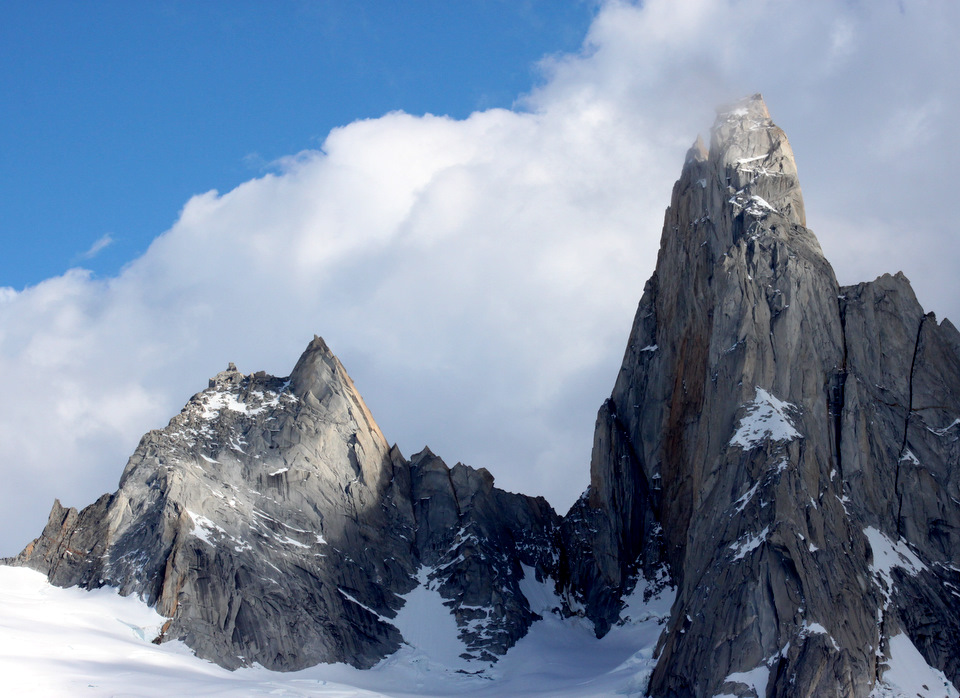
The path didn’t waste any time gaining elevation, but we were fresh and felt good- the crisp air, the utter quite, and the sparkle of the rising sun reflecting off the dew soaked foliage put a bounce in our step. Before we knew it, we had gone several miles, left the chromatic forest behind, crossed a few rivers and a large swampy field, and were now at the bottom of a steep, boulder strewn hill, that seemed to keep going up forever. This massive hill was actually a glacial moraine, a pile of debris left over from the bulldozing action of a slowly advancing, but now receded, glacier. We climbed upward, step after step, until our legs burned. It felt like we had been doing this for hours. The valley fell away below us, but looking up the mountain, there was no end in sight for the trail. We must have gained a couple thousand feet, and I was beginning to doubt the value of subjecting ourselves to this stair stepping torture, when we crested the top of the moraine and saw Mt. Fitzroy in all its glory.
A huge tower of granite thrust defiantly into the sky, flanked by lesser peaks and encircled by ancient glaciers, that curved down the high valleys like frozen rivers, crisscrossed with regular cracks and fissures, like the wizened creases on an old man’s face. The most prominent of these glaciers came to an abrupt end in the small lake that sits cradled behind the massive moraine we had just climbed and the foot of the mountain. The lake’s water was freezing cold, crystal clear, and because we were so high and far from any source of contamination, entirely potable. I have to say that there is no satisfaction quite like drinking cold, pristine water, directly from a lake. This is how it should be- everywhere.
We sat and contemplated the grandeur of it all. The lake, the glaciers, the immense blue sky. And that absurdly huge pillar of rock, boldly poking straight up in the air- it was almost like the earth was giving us a thumbs-up for making it this far- both up the mountain, and on the extent of our trip. The very peak of Mt. Fitzroy was topped by a cap of rolling clouds, and though they did add to the surreal nature of the scene, we hoped they would clear so we could get a good view of the whole mountain. So we waited. We ate our sandwiches, shot some photos, and even took a short nap. But after a while the wind picked up and turned the mirror finish surface of the water into a rough and troubled sea. We decided that that was our queue to leave, and started back down the mountain. It was a good thing we left when we did, for not ten minutes after we made it to the bottom of the moraine, I looked over my shoulder and the whole of the peak, including the area where we had been sitting, was shrouded in a black, menacing storm cloud.
I was a little disappointed that the clouds at the summit never blew off, but overall I felt lucky that the weather had been beautiful and sundrenched for most of the day. We had heard recent stories of trips up to the lake that had been thwarted by dense fog and constant rain. Even though we didn’t get that perfect photo of Mt. Fitzroy, I look at it as now we just have a good reason to go back some day.
Prev ChapterNext Chapter


